This page contains maps of four Empires that came after the end
of the Roman Empire, which were "successors" in the sense that they
contained
an Imperial city (Rome or New Rome). I compare them at their height to
the Roman Empire at various times. In addition, I include the kingdom
of
Greece,
even though this was not an Empire and did not include New Rome.
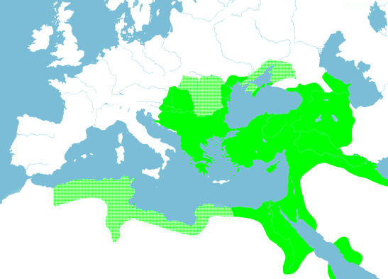
The first successor Empire came into being immediately following the
end of the Roman Empire in 1453, when the Ottoman Sultan Mehmet II
captured Constantinople. Thereafter titled "the Conquerer", Mehmet
declared himself Qaysar
(Caesar) as well as Sultan, and some Greek scholars accepted him as the
new Emperor of the Romans. Named after its first ruler, Osman
(1280-1324), the Ottoman Empire grew
fairly steadily for three centuries to the early 17th century. It then
declined fairly steadily for another three centuries until its end in
1923
when the modern state of Turkey replaced it. Above it is shown at its
peak,
in 1606, following the successful conclusion of a war with the Hapsburg
Empire which extended the Ottomans' hold over Hungary. In the east,
however,
a war since 1603 with Safavid Persia was going badly, and would lead to
the loss of significant territory by 1639. The Ottoman
territories shown here
are
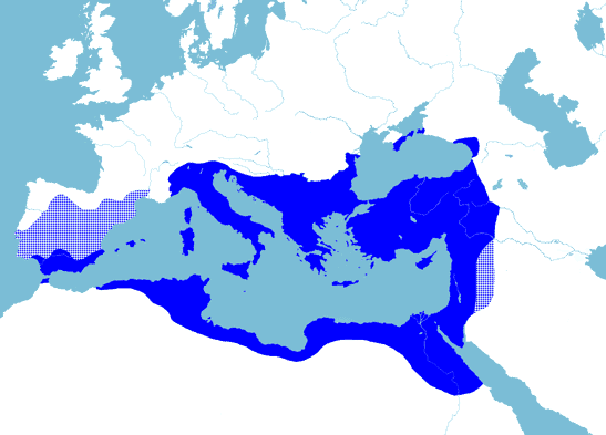
comparable to those of the Byzantine Empire at its peak under
Justinian,
roughly 1000 years earlier. The Byzantine Empire at this time extended
a lot further west,
but
the Ottoman Empire extended considerably further east, north, and
south.
The
Byzantine
Empire lasted almost 900 years after its peak; the Ottoman Empire
little
more than 300.
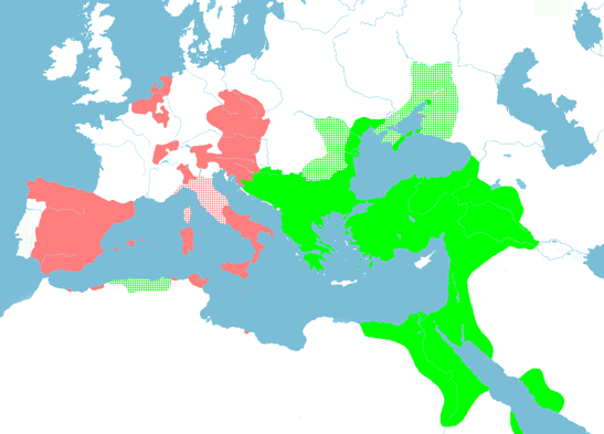
The second successor Empire was the Hapsburg Empire of Charles V. He
originally (1515) held only the former Burgundian territories on the
border between France and Germany, but by accidents of deaths and
marriages, Charles ended up inheriting also Castille (with its Empire
in the New World) and Aragon (with its Mediterranean Empire) in 1516;
the Hapsburg lands in Austria and the title of Holy Roman Emperor in
1519; and Bohemia and Hungary (disputed) in 1526. His Empire reached
its maximum when he annexed Milan and Tunisia in 1535, all of the
Netherlands in 1536, and reached a settlement in Hungary in 1538 which
left him with the western part. By 1530 he had also made the Patrimonium
Petri (together with much of the rest of Italy), dependencies of
his
Empire. This, and his coronation as Holy Roman Emperor by the Pope in
that year (the last such coronation), justifies the colouring of his
Empire in pale red --- it was almost the
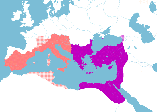
Western Roman Empire reborn. The same is true of the comparison Empire,
that of Theodoric the Great, king of the Ostrogoths, almost 1000 years
earlier. Having overthrown Odovacer as king of Italy at the behest of
the eastern Emperor Zeno in 493, Theodoric acted much more as an equal
to his counterpart in Constantinople. Emperor Anastasius returned the
western Imperial regalia in 497, and Theodoric was Emperor in all but
name. Thus his Empire is shown in pale red
without the purple stippling used for Odovacer's
kingdom in the 19 maps page. Theodoric also reconstituted much of
the Western Empire, ruling the Visigoths in Spain from 511 onwards, and
exerting hegemony over the Vandals in Africa from 500 to 523. His
Empire (not reproduced elsewhere on
this site) reached its maximum in that year when he annexed
southern Burgundy and made the rest a dependency. The Visigothic and
Ostrogothic kingdoms were separated on Theodoric's death in 526, and
Rome fell to Emperor Justinian ten years later. Similarly, on the
retirement of Charles V in 1556, his Empire was split between the
Austrian Hapsburg Empire (including the Imperial title) and the Spanish
Hapsburg Empire, but Spain maintained its power in Italy for a century
and more longer. The above maps also show the Ottoman Empire and the
(Eastern) Roman Empire, and their extents at these times were also
remarkably similar.
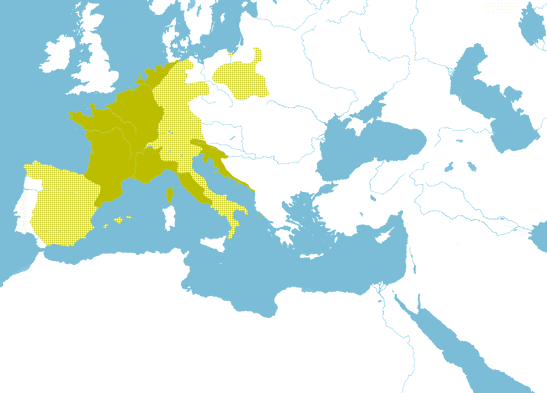
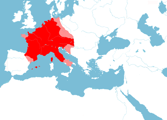
The third successor Empire was Napoleon's Empire of the French. As the most successful general of the French revolution, Napoleon made himself dictator of France in 1799. In imitation of Classical Rome, he took the title of First Consul. In 1804, he followed the lead of that earlier Emperor of the Franks, Charlemagne, by being crowned Emperor in Rome. Pointedly unlike Charlemagne, however, he took the crown from the Pope and placed it on his own head himself. In 1809 he annexed the Papal States, bringing Rome into his Empire. His Empire reached its height in 1812 as shown above. The stippled areas were mostly ruled by members of Napoleon's family. Of the great powers, only Britain and Russia remained in opposition to him. In 1812 he marched east with an army of half a million men to bring the Czar into line. This campaign was a disaster, and the next year all of Europe rose against him. With his final defeat in 1815, Napoleon's Empire crumbled to nothing. Yet at its height, it was well comparable to Charlemagne's Empire 1000 years before.
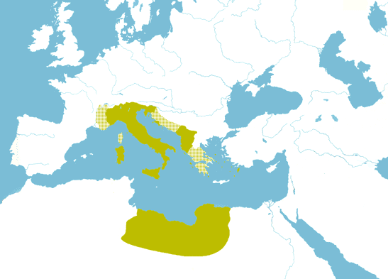
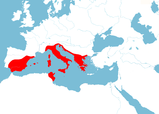
The fourth successor Empire was Mussolini's Fascist Italian Empire (1922-1943). It was named after the Fasces, a bundle of sticks symbolizing authority in the ancient Republic of Rome. Mussolini portrayed himself as the new Julius Caesar, and then the new Augustus. Around the turn of the century the kingdom of Italy had conquered Somalia (south of this map) and Libya in Africa. Mussolini's only real success at Empire building was his annexation of Ethiopia (also south of this map) in 1936 and Albania in 1939. In the Second World War, Italian forces were at first humbled by the Greek army. The Italians were able to annex (solid) or occupy (stippled) the European territories shown above only with German assistance. Just one year later Italy was invaded by the British and Americans, and Mussolini overthrown. At its height, the Fascist Italian Empire plus the areas it occupied was comparable to the Empire of Republican Rome in 146 BC, when it had just become indisputably the greatest power in the northern Mediterranean. The map for this time is not reproduced elsewhere in this site.
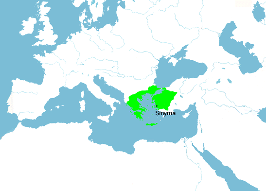
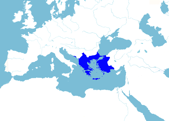
The last state shown does not strictly belong, as it was not an
Empire,
and did not contain New Rome. However, I could not resist showing the
Greek
Kingdom in 1921. This was after the First World War, when the Ottoman
Empire
was on the losing side. Its territories south of Anatolia and Armenia
had
already been lost to British and French forces, and much of its other
territories
occupied by the Allies (Britain, France, Italy and Greece). In 1920 the
Allies decided to recreate a large Armenian state, give Smyrna and
its hinterland to Greece, and make Constantinople and the straits an
international
area. The Ottoman Sultan agreed to these terms, but nationalist Turks
refused
to accept this further loss of territory. In the ensuing civil war,
Greece
saw its chance to recreate a Greek state encompassing western Anatolia
as well as European Greece. By 1921 Greek forces controlled the area
shown
above (also including southern Albania, which was occupied 1918-23).
With the notable exception of Constantinople, most of the
area held by the Byzantine Empire before its collapse in 1204 was
briefly under Greek control again. (The map of the Byzantine Empire in
1204 is
not one of the 19 main maps.)
But the nationalist Turks under
Kemal
(later Attaturk) won their civil war, and by 1923 had beaten the Greek
army and negotiated the withdrawal of the other Allied forces.
Following
this, both sides expelled their ethnic minorities, so that western
Anatolia
became overwhelmingly Turkish for the first time, and the southern
Balkans
(apart from Istanbul and its hinterland) overwhelmingly Greek. There
was
to be no Byzantine restoration, and no demographic justification for
one
in the future.